

Let’s say you were trying to get to Focus Towers. But the year was 1892, not 2022. You ask around. Someone, perhaps your average time traveler on the corner, directs you to Atwood Street. They would be right on target but you and I, bound as we are by the context of our times, would have no idea about where we need to go.
The confusion over Hickory thoroughfares has been around almost as long as the city itself. Prior to around 1914, Hickory streets were designated by names, not numbers. For example, the avenue that now serves as the parking lot on Union Square, just north of the railroad tracks was once a regular road known as Morganton Street. Crossing Morganton to the east was Shuford Street, to the west Watauga Street. Parallel to the railroad tracks, which were there a decade before Hickory became a town, was Lincoln Street.
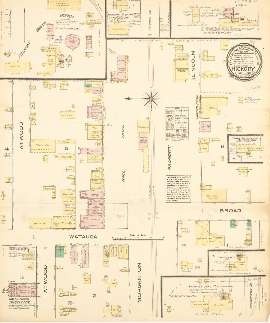
Photo: 1885 map of Hickory. Streets have since gone through two name changes.
In those days, the downtown commons area was not known as Union Square. It was called Park Place because that’s where wagons coming down from the mountains with their produce parked and camped. They sold their wares from the back of the wagons, then headed back to family farms until the next crop was ready for sale. If you think about it, that’s not much different from the farmers market of today.
Some folks would like to go back to named streets. But by around 1914, city leaders decided that numbers were a better identifier. However, they did not choose the system used today. Time traveling to Focus World Headquarters then would land you on 11th Street. They did begin to use the designation of streets for north/south roads and avenues for east/west routes. The numbers for streets started at the southern edge of the town’s boundary while First Avenue was located somewhere beyond Lenoir College (as it was called at the time).
Ideally, uncertainty should be at a minimum as to how the street system works. Until the early 1950s, Hickoryites lived with and learned the classification but continued confusion prompted officials to look for a better solution. Hickory expanded its borders tremendously in those years, taking in West Hickory and Highland, so a logical, understandable map had to be drawn that helped everyone get where they were going. That’s when the muddle on the road kicked into another gear.
As the 20th century progressed and automobile traffic having taken over the roadways, the speed of life on Hickory streets got much faster. In 1950, John Parker, head of UNC’s center for city planning was hired to straighten it all out and urbanize Hickory. He divided the city into quadrants, which means NW, SW, NE, SE became very important to getting to the right spot. That was good but for streets in a grid but roads sometimes meander which means designations of ‘circle,’ ‘drive,’ ‘way,’ ‘court,’ and ‘place’ that confuse the issue were also used. As one assistant city manager once said, “there is some logic behind it, even if it doesn’t appear that way on the surface.” He was right.
Some folks would still rather live on a cozy-named thoroughfare like Maple Street. But despite the fact that a few residents have called the grid we use today “engineering madness,” consider the fact that the current system allows emergency services to know exactly where they are going when most needed. Efforts to change the system in 1989 were rejected for that reason and the streets retain the names they were given 61 years ago, the longest streak in Hickory’s history.
With GPS, it’s not a big deal anymore. By the way, Focus Towers is located on First Avenue, Northwest.


